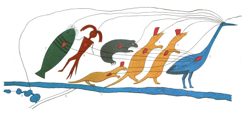
In Maps Are Territories (1989), David Turnbull offers this as an example of a map that “can only be understood within the cultural specifics of the circumstances that it portrays.” It’s a Chippewa land claim presented to the U.S. Congress in 1849. The rightmost figure is the totem of the chief, who is of the Crane clan. Following him are members of allied clans — Martens, Bears, Man-Fish, and Catfish.
“To the eye of the bird standing for this chief, the eyes of each of the other totemic animals are directed as denoted by lines, to symbolize union of views,” explained ethnologist Henry Schoolcraft. “The heart of each animal is also connected by lines with the heart of the Crane chief, to denote unity of feeling and purpose. If these symbols are successful, they denote that the whole forty-four persons both see and feel alike — that they are one.”
The line drawn forward from the crane’s eye denotes the course of his journey, and another line is drawn backward to a series of small lakes for which he is seeking the grant. The long parallel lines below the figures represent Lake Superior, and the small parallel lines that diverge from this represent a path from its shore to the villages and interior lakes where the Chippewa hope to live.
Schoolcraft wrote in 1851, “The entire object is thus symbolized in a manner which is very clear to the tribes, and to all who have studied the simple elements of this mode of communicating ideas.”
(H.R. Schoolcraft, Historical and Statistical Information Respecting the History, Condition and Prospects of the Indian Tribes of the United States, Volume I, 1851, 416-417.)