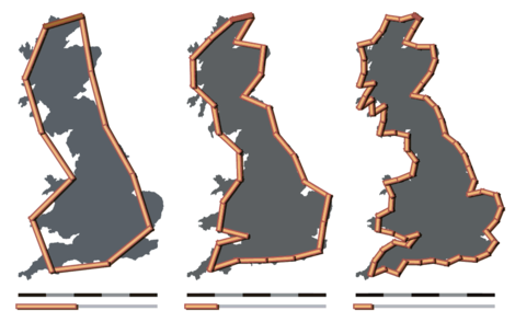
How long is a coastline? If we measure with a long yardstick, we get one answer, but as we shorten the scale the total length goes up. For certain mathematical shapes, indeed, it goes up without limit.
English mathematician Lewis Fry Richardson discovered this perplexing result in the early 20th century while examining the relationship between the lengths of national boundaries and the likelihood of war. If the Spanish claim that the length of their border with Portugal is 987 km, and the Portuguese say it’s 1,214 km, who’s right? The ambiguity arises because a wiggly boundary occupies a fractional dimension — it’s something between a line and a surface.
“At one extreme, D = 1.00 for a frontier that looks straight on the map,” Richardson wrote. “For the other extreme, the west coast of Britain was selected because it looks like one of the most irregular in the world; it was found to give D = 1.25.”
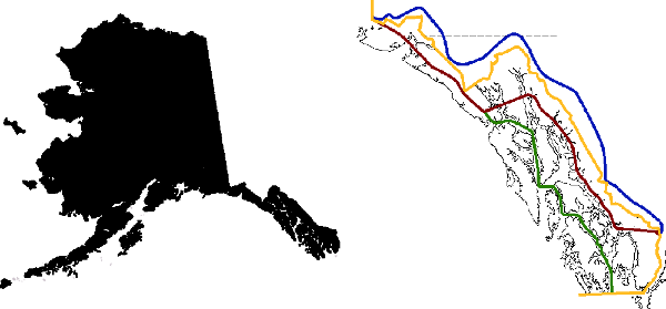
This is a mathematical notion, but it’s also a practical problem. On the fjord-addled panhandle of Alaska, the boundary with British Columbia was originally defined as “formed by a line parallel to the winding of the coast.” Who gets to define that? On the map below, the United States claimed the blue border, Canada wanted the red one, and British Columbia claimed the green. The yellow border was arbitrated in 1903.